Top 5 Drone Mapping Software 2023
Drone mapping is an indispensable tool in today’s fast-paced, technologically advanced world. It has revolutionised numerous industries, from agriculture and real estate to construction and environmental conservation. By providing a bird’s-eye view of large areas, drone allows for detailed analysis and insights that were previously impossible or extremely time-consuming to obtain.
The importance of drone mapping lies in its ability to capture high-resolution aerial data and transform it into actionable insights. It enables professionals to make informed decisions based on accurate, up-to-date information. For instance, farmers can monitor crop health and optimise irrigation, construction managers can track progress and identify potential issues, and environmental scientists can study changes in ecosystems over time.
Choosing the right drone mapping software is critical to maximising these benefits. The right software can streamline your operations, improve accuracy, and save time and resources. It should offer features like high-quality image processing, user-friendly interface, robust data analysis tools, and seamless integration with other systems.
As we move into 2023, technology continues to evolve, and so does drone mapping software. With numerous options available, it can be challenging to choose the best one for your needs. That’s why we’ve compiled a list of the top 5 drone mapping software of 2023 to help you make an informed decision.
Drone mapping is an indispensable tool in today’s fast-paced, technologically advanced world. It has revolutionised numerous industries, from agriculture and real estate to construction and environmental conservation. By providing a bird’s-eye view of large areas, drone mapping allows for detailed analysis and insights that were previously impossible or extremely time-consuming to obtain.
The importance of drone mapping lies in its ability to capture high-resolution aerial data and transform it into actionable insights. It enables professionals to make informed decisions based on accurate, up-to-date information. For instance, farmers can monitor crop health and optimise irrigation, construction managers can track progress and identify potential issues, and environmental scientists can study changes in ecosystems over time.
Choosing the right drone mapping software is critical to maximising these benefits. The right software can streamline your operations, improve accuracy, and save time and resources. It should offer features like high-quality image processing, user-friendly interface, robust data analysis tools, and seamless integration with other systems.
As we move into 2023, technology continues to evolve, and so does drone mapping software. With numerous options available, it can be challenging to choose the best one for your needs. That’s why we’ve compiled a list of the top 5 drone mapping software of 2023 to help you make an informed decision.
Pix4Dmatic
Pix4Dmatic is a cutting-edge software that’s revolutionising the field of professional drone and terrestrial mapping. Available in a multitude of languages, it’s designed to handle large datasets with ease, processing thousands of images while maintaining survey-grade accuracy. This results in a 50% faster processing time without compromising on precision.
One of the standout features of Pix4Dmatic is its fully automated processing. Developed in collaboration with surveyors and mapping professionals, it allows users to import, process, and assess the quality of a project in just a few clicks. This streamlined workflow extends to a seamless transition from Pix4Dmatic to Pix4Dsurvey.
Drone mapping is an indispensable tool in today’s fast-paced, technologically advanced world. It has revolutionised numerous industries, from agriculture and real estate to construction and environmental conservation. By providing a bird’s-eye view of large areas, drone allows for detailed analysis and insights that were previously impossible or extremely time-consuming to obtain.
The importance of drone mapping lies in its ability to capture high-resolution aerial data and transform it into actionable insights. It enables professionals to make informed decisions based on accurate, up-to-date information. For instance, farmers can monitor crop health and optimise irrigation, construction managers can track progress and identify potential issues, and environmental scientists can study changes in ecosystems over time.
Choosing the right drone mapping software is critical to maximising these benefits. The right software can streamline your operations, improve accuracy, and save time and resources. It should offer features like high-quality image processing, user-friendly interface, robust data analysis tools, and seamless integration with other systems.
As we move into 2023, technology continues to evolve, and so does drone mapping software. With numerous options available, it can be challenging to choose the best one for your needs. That’s why we’ve compiled a list of the top 5 drone mapping software of 2023 to help you make an informed decision.
Pix4Dmatic
Pix4Dmatic is a cutting-edge software that’s revolutionising the field of professional drone and terrestrial mapping. Available in a multitude of languages, it’s designed to handle large datasets with ease, processing thousands of images while maintaining survey-grade accuracy. This results in a 50% faster processing time without compromising on precision.
One of the standout features of Pix4Dmatic is its fully automated processing. Developed in collaboration with surveyors and mapping professionals, it allows users to import, process, and assess the quality of a project in just a few clicks. This streamlined workflow extends to a seamless transition from Pix4Dmatic to Pix4Dsurvey.
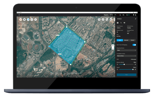
DJI Terra
DJI Terra is a 3D model reconstruction software that uses photogrammetry as its core technology. It’s designed to support accurate and efficient 2D and 3D reconstruction of visible light, and data processing through DJI LiDAR.
The software is capable of generating realistic 3D models in three resolutions—high, medium, and low. It uses AI technology to automatically optimise water surfaces in the model, and exports the formats commonly used in diverse scenarios, such as surveying and mapping, accident sites, power grid equipment, and progress-tracking for construction projects.
Not only does this make it easier than ever to manage and analyse your data, but it also allows for a seamless export of processed projects. This compatibility with Pix4Dsurvey enables users to transform point clouds into actionable, CAD-ready data, further enhancing its utility and efficiency.
Pix4Dmatic also supports a full terrestrial workflow, allowing users to process LiDAR and RGB image outputs from Pix4Dcatch. This integration of photogrammetry and LiDAR technology provides a comprehensive mapping solution.
The software excels in creating accurate 3D maps and models from thousands of images. Users can generate dense point clouds, orthomosaics, digital surface models (DSM), and 3D textured meshes. It also offers easy accuracy checks with support for vertical coordinate systems and geoid.
Pix4Dmatic is not just about speed and accuracy; it’s also about delivering results quickly. It offers fast development cycles, providing essential outputs in a fraction of the time without sacrificing accuracy.
Users have praised Pix4Dmatic for its speed and efficiency, particularly when handling large projects. It’s been described as a game-changer, enabling users to push their drone datasets to their limits, making no project size off-limits.
The M3M’s precise positioning with centimetre-level RTK and microsecond-level time synchronisation ensures accurate data collection. Capable of surveying up to 200 hectares per flight, the Mavic 3 Multispectral offers quick and comprehensive coverage of fields, making it a powerful tool for precision agriculture.
DJI Terra
DJI Terra is a 3D model reconstruction software that uses photogrammetry as its core technology. It’s designed to support accurate and efficient 2D and 3D reconstruction of visible light, and data processing through DJI LiDAR.
The software is capable of generating realistic 3D models in three resolutions—high, medium, and low. It uses AI technology to automatically optimise water surfaces in the model, and exports the formats commonly used in diverse scenarios, such as surveying and mapping, accident sites, power grid equipment, and progress-tracking for construction projects.
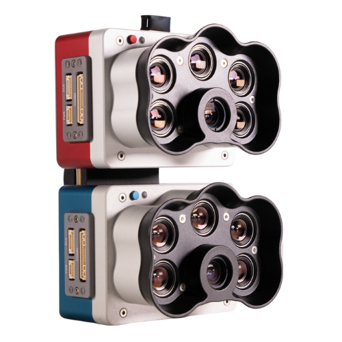
AgEagle MicaSense RedEdge-P Dual Camera
The AgEagle MicaSense RedEdge-P Dual Camera is a high-resolution multispectral drone camera that brings a host of benefits to precision agriculture. Its purpose-built optics and industrial image sensors, coupled with narrowband, scientific-grade filters, provide detailed and accurate data for monitoring crop health and optimising agricultural practices.
Despite its advanced capabilities, the RedEdge-P Dual Camera is compact and lightweight at 745 grams, making it easy to transport and is compatible with the DJI Matrice 300 & Matrice 350 RTK airframes. Its power efficiency, with an external power input of 7.0 V – 25.2 V, ensures longer operational times, allowing for extensive data collection in a single flight.
DJI Terra’s algorithm is optimised according to different scenarios to significantly improve processing efficiency, effectively avoid image warping and deformation, and obtain detailed and accurate measurement results for all target objects and survey areas.
One of the unique features of DJI Terra is its ability to perform highly accurate processing of the point cloud data captured by the Zenmuse L1 (LiDAR). This includes route calculation, accurate merging of point cloud and visible light data, optimisation of point cloud accuracy, extraction of ground points, and generation of fieldwork reports.
DJI Terra supports real-time 3D mapping. When efficiency is key, you can quickly render and visualise a 3D model of the mapped area. This allows you to make decisions based on the preliminary model and check for completeness immediately or plan 3D flights on-site.
The software also offers detailed inspection mission planning. It can automatically generate waypoints and flight routes based on one or more points selected in a local realistic 3D model or point cloud. A simulated camera view that includes the selected point is displayed on screen to enable better waypoint selection and more efficient flight route planning, automating inspection workflows.
Trendspek
Trendspek is a game-changer in the drone mapping industry, offering Precision Reality Twins that take digital twins to the next level. With Trendspek, you can glide around a model that is virtually indistinguishable from the original asset, providing a level of detail and accuracy rarely seen in the industry.
Designed for speed, Trendspek processes drone, robot, and other input at super speeds, reducing render time from a week to a day for even the most complex assets. This speed and efficiency make Trendspek a valuable tool for managing data and detail. Trendspek delivers the world’s most intelligent Precision Reality Twins, mirroring reality with awe-inspiring accuracy. This level of detail introduces true data into asset management, preserving asset value over time and eliminating guesswork.
Hosted on the cloud and built to unite teams in one digital workspace, Trendspek brings experts together from across the globe with simple, accessible, and safe in-model communication. This collaborative approach supports truly effective teamwork.
The RedEdge-P Dual Camera captures a wide range of spectral bands, including coastal blue, blue, green, red, red edge, and near-IR. This broad-spectrum coverage provides comprehensive data about plant health, including information about chlorophyll content, plant vigour, and more. The camera also provides RGB colour output, offering a more familiar visual representation of the field for easier interpretation.
With a capture rate of up to 3 images per second in raw DNG format, the RedEdge-P Dual Camera can quickly cover large areas, making it ideal for large-scale farming operations. The ground sample distance (GSD) for multispectral bands is 7.7 cm per pixel at 120 m altitude, and for panchromatic and pansharpened images, it’s 3.98 cm per pixel at the same altitude. This means that even from a high altitude, the camera can capture detailed images, providing precise and accurate data for analysis.
The AgEagle MicaSense RedEdge-P Dual Camera is a powerful tool for precision agriculture, offering detailed and accurate data collection, ease of use, and flexibility. Its advanced features and capabilities can help farmers and agricultural professionals make informed decisions, optimise their practices, and ultimately, increase productivity and sustainability.
Furthermore, Trendspek is dynamic, offering traditional PDF output and enhancing reporting with in-built, shared annotations. Each Precision Reality Twin is its own interactive account of asset condition and key recommendations, enabling efficiency.
Finally, Trendspek ensures safety with its ISO27001 accredited, pen-tested platform. Centralised storage facilitates sharing, and impenetrable digital walls protect your data.
Agisoft Metashape
Agisoft Metashape is a versatile photogrammetry software that supports a wide range of imagery types, including aerial, close-range, and satellite. It’s designed for professional use in fields like architecture, construction, GIS, and visual effects.
Agisoft Metashape offers photogrammetric triangulation, dense point cloud editing and classification, and digital elevation model (DEM) generation and editing. It’s capable of creating georeferenced orthomosaics and 3D models with photorealistic textures. The software also supports LiDAR data and provides tools for measurements, stereoscopic measurements, and panorama stitching.
AgEagle MicaSense RedEdge-P Dual Camera
The AgEagle MicaSense RedEdge-P Dual Camera is a high-resolution multispectral drone camera that brings a host of benefits to precision agriculture. Its purpose-built optics and industrial image sensors, coupled with narrowband, scientific-grade filters, provide detailed and accurate data for monitoring crop health and optimising agricultural practices.
Despite its advanced capabilities, the RedEdge-P Dual Camera is compact and lightweight at 745 grams, making it easy to transport and is compatible with the DJI Matrice 300 & Matrice 350 RTK airframes. Its power efficiency, with an external power input of 7.0 V – 25.2 V, ensures longer operational times, allowing for extensive data collection in a single flight.
Agisoft Metashape is not just about data processing; it’s also about automation and customisation. It offers Python and Java API for sophisticated automation and customisation options, from adding custom processing operations to the application GUI to complete job automation and integration into Python or Java pipeline.
The software also supports network processing, allowing distributed calculations over a local computer network for processing huge data sets in one project. Additionally, it offers cloud processing, which saves on hardware infrastructure and allows for online visualisation and sharing of processing results.
ContextCapture
Bentley ContextCapture is a powerful software solution that allows you to capture, analyse, and share existing conditions of any infrastructure project. It enables the automatic generation of multi-resolution 3D models at any scale and precision, using photographs or LiDAR point clouds.
ContextCapture is designed to handle projects of all sizes, from small-scale sites to entire cities. It leverages grid computing to dramatically speed up processing time by running multiple engines on several computers and associating them to a single job queue. This makes it capable of handling extremely large projects with ease.
The software offers a range of capabilities, including the ability to input unlimited data, produce multi-resolution meshes of unlimited scale and precision, and deliver projects on time by leveraging parallel processing. It also includes 3D machine-learning technology to automatically detect, locate, and classify your reality data.
The RedEdge-P Dual Camera captures a wide range of spectral bands, including coastal blue, blue, green, red, red edge, and near-IR. This broad-spectrum coverage provides comprehensive data about plant health, including information about chlorophyll content, plant vigour, and more. The camera also provides RGB colour output, offering a more familiar visual representation of the field for easier interpretation.
With a capture rate of up to 3 images per second in raw DNG format, the RedEdge-P Dual Camera can quickly cover large areas, making it ideal for large-scale farming operations. The ground sample distance (GSD) for multispectral bands is 7.7 cm per pixel at 120 m altitude, and for panchromatic and pansharpened images, it’s 3.98 cm per pixel at the same altitude. This means that even from a high altitude, the camera can capture detailed images, providing precise and accurate data for analysis.
The AgEagle MicaSense RedEdge-P Dual Camera is a powerful tool for precision agriculture, offering detailed and accurate data collection, ease of use, and flexibility. Its advanced features and capabilities can help farmers and agricultural professionals make informed decisions, optimise their practices, and ultimately, increase productivity and sustainability.
With a capture rate of up to 3 images per second in raw DNG format, the RedEdge-P Dual Camera can quickly cover large areas, making it ideal for large-scale farming operations. The ground sample distance (GSD) for multispectral bands is 7.7 cm per pixel at 120 m altitude, and for panchromatic and pansharpened images, it’s 3.98 cm per pixel at the same altitude. This means that even from a high altitude, the camera can capture detailed images, providing precise and accurate data for analysis.
The AgEagle MicaSense RedEdge-P Dual Camera is a powerful tool for precision agriculture, offering detailed and accurate data collection, ease of use, and flexibility. Its advanced features and capabilities can help farmers and agricultural professionals make informed decisions, optimise their practices, and ultimately, increase productivity and sustainability.
ContextCapture also provides easy-to-use touch-up tools for quickly cleaning up your reality meshes, precision analysis and measurement tools for your reality meshes, and the ability to produce 3D models in a full range of GIS formats to integrate them into any workflow.
Moreover, ContextCapture enables online streaming of multi-resolution reality meshes made of billions of triangles, optimised for streaming and web publishing. This makes it a versatile tool for a wide range of applications, from infrastructure planning and design to asset management and inspection.
Best software for data presentation: Nira
You’ve collected your data, and processed it and now you need to wow your client. Nira is what you need.
Powerful & Secure: Nira supports real-time Physically-Based Rendering (PBR), with UDIM textures of up to 32K and polycounts in the billions on any device, including resource-constrained mobile hardware.
Inspect & Review: Pinpoint production issues early using Nira’s built-in mesh and animation inspection tools. Match your pipeline’s unique look with pixel-perfect accuracy by integrating custom shaders or renderers.
Click here to preview Nira’s software. This was created using images captured by a PhaseOne iXM camera, which was processed using Pix4Dmapper and transferred to Nira for client viewing.
AgEagle MicaSense RedEdge-P Dual Camera
The AgEagle MicaSense RedEdge-P Dual Camera is a high-resolution multispectral drone camera that brings a host of benefits to precision agriculture. Its purpose-built optics and industrial image sensors, coupled with narrowband, scientific-grade filters, provide detailed and accurate data for monitoring crop health and optimising agricultural practices.
Despite its advanced capabilities, the RedEdge-P Dual Camera is compact and lightweight at 745 grams, making it easy to transport and is compatible with the DJI Matrice 300 & Matrice 350 RTK airframes. Its power efficiency, with an external power input of 7.0 V – 25.2 V, ensures longer operational times, allowing for extensive data collection in a single flight.
Summary
The landscape of drone mapping software continues to evolve, with each year bringing new advancements and improvements. The top drone mapping software of 2023, including PiX4Dmatic, DJI Terra, Trendspek, Agisoft Metashape, and Bentley ContextCapture, each offer unique features and capabilities that can significantly enhance the efficiency and effectiveness of your operations.
Whether you’re looking for software that offers seamless integration with other tools, advanced 3D modeling capabilities, detailed asset management, or robust photogrammetry features, there’s a solution out there that can meet your needs. The key is to understand your specific requirements and choose the software that best aligns with them.
Remember, the right drone mapping software can make a significant difference in your operations, helping you capture accurate, high-quality data, streamline your workflows, and make informed decisions. So, take the time to explore these top options and find the one that’s right for you. The future of drone mapping is here, and it’s more exciting than ever.